Exploring the Conemaugh Gap - The deepest gorge East of the Mississippi cacicia@hotmail.com - Johnstown, Pennsylvania
Showing posts with label Browns Farm. Show all posts
Showing posts with label Browns Farm. Show all posts
Saturday, April 7, 2012
Saturday, March 24, 2012
Turtle-tad
I find this possible structure so interesting. Sort of looks like a cross between a tadpole and a turtle. It's a low to the ground wall (tail) and it has a rounded end - that looks like the head of a turtle. Given the history of this piece of land - there was a Native American woman married to a free African-American man around 1800. She along with their eight children died before 1820. This area also has a large wall along with a couple of rockpiles and what's lefdt of a very large and old chestnut tree.
Saturday, March 3, 2012
Mounds and Skull - Lower Yoder Township
It was just a beauitful day for being in the woods. Spotted this large, mess of a rock mound right off the bat.
RJ is standing on what's left of am old military road that probably dates from the French and Indian War.
Showing off a section of the originial Mountain Road - that dates to at least 1774 according to 'Frontier Forts of Western Pennsylvania'.
I just can't seem to ever stay from this stone skull - I always take a couple of shots of it when passing this way.
I think I am about the only one that thinks this is something - and I always will.
This is the first mound I ever found many years ago and it will always continue to be my favorite. This is about 1/2 mile from the stone skull.
Closeup - but around the other side
A hollow - that looks like it was built that way.
Found this new small rockpile nearby.
Monday, May 17, 2010
Stone Road - Lower Yoder Township
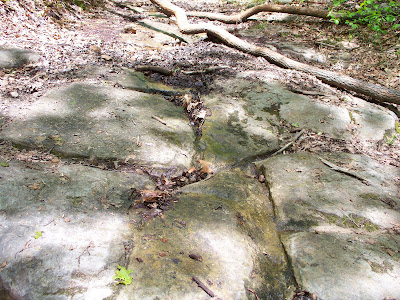
Knowing that there is yet more rain in the forecast coming up. I thought I'd better head up to Brown's and put some fresh flags on the graves of a couple of Black Civil War Veterans. The old ones have seen better days. As I was walking up the old road that has been here since at least 1774 - for more on the history click cambriahistory.blogspot.com. I use this old road so much and take it's age for granted. Which means I've hardly ever photographed it. So I thought on saturday, it's about time I do. Some of it is made up of bedrock, but other sections are made up of what looks like quarried chunks of stone layed flat as a road surface.
All in all about 60% of the road going up is made up of stone and rock like this. And even in wet weather, it stays in better shape compared to dirt roads. I think this road is a perfect example of an old Indian type trail written and explained in depth by Paul Wallace in is 'Indian Trails of Pennsylvania' book. 

As you can see, the old road is still in great shape. And what makes this road even more important in my mind is that near the end of it is one of my old and much photographed favorite structures. I can't help thinking that the road and this structure are somehow connectioned. If you ask me, I think it's on a shamantic level.
Turning and looking at the end of this road up top.
Heading now to Brown's I enjoy always being greeted by what I call the 'three sisters'. These old apple trees are the only ones left standing from a 150 year old orchard that used to be here.
There are at least 77 people if not more buried in the old family cemetery. The first burial occured in 1827, when 80 year old Elizabeth Harshberger (William's mother) died after arriving by wagon train from Lancaster County. I just thought it would be nice with Memorial Day coming up, to honor the couple of old vets up there with some fresh flags.
I didn't realize that the War Markers use a smaller type flag, so I just stuck them next to the markers.
Monday, February 15, 2010
Browns Farm - Johnstown - Lower Yoder Township - John Smith Obit
This is the obituary of John Smith (died January 1895) - he was the son of Ebinburg Smith who settled this part of the Laurel Hill back in the late 1700's to early 1800's. He was of African-American/Native American heritage, which makes this story even more interesting. This aspect of the history I will be writing about in future posts.
This is the burial plot - it's hard to tell just how many people are buried here. My last count was at least 77 burials if not more. That is not a mound in the background - but a small pond put in by Elmer Brown (the last owner of the farm). Many a Morrellville kid enjoyed a summer swim in this popular waterhole.
Coming up in future posts. I will be talking about John Smith's Civil War Service.
For more history on the Browns and Smiths click http://cambriahistory.blogspot.com/
Thursday, January 21, 2010
Brown's - Lower Yoder Township
This rockpile made up of flat-type rocks is located just off the dirt road heading to Brown's from the Sons of Italy Road. This is one of two there that I have found so far.
Tuesday, January 19, 2010
Rockpiles at Brown's Farm - Lower Yoder
This pile from the way it looks and is laid out - reminds me of an old-time grave.
These two rockpiles are part of group of many. They go from small to large.
These two rockpiles are part of group of many. They go from small to large.
Wednesday, December 2, 2009
Split Wedged Rock - Brown's Cemetery
Possible cairn with triangle shaped rock. On the far left of the screen is a possible split wedged rock.
This is a close up of the structure that is located on the upper left of the above picture.
This is a close up of the above structure. All these things are located very close to each other - actually on the site of a very old farmstead from the early 1800's. A free slave settled in this section of the mountain after marrying a Native American. The site is about 800 acres. Most of which I am still exploring.
This is a side shot - close up of yet another triangle like rock that I cleaned a bit of it off because I saw what looks like that rectangle rock sitting on top of it.
This picture is a bit on the bright side. But what I am trying to show is yet another triangle rock that looks like it's part of a cairn with another cairn like structure to the right front of it.
Sunday, November 22, 2009
Possible Native American Indian Burial Mound - Brown's Farm
This elongated cairn (rock pile)is believed to be a burial. I believed it to contain the wife of Edenborough Smith the first owner of Brown's. In an old obit, they say she was an "Indian Squaw" who died in childbirth. The child I believe to be John Smith (Civil War Vet). I believe that Brown's is the site of a former Native American village. This whole area sits near the Cambria-Westmoreland County line.
Edenborough Smith was a free African who settled in this part of Western Pennsylvania around 1800 or so. Some sources say he settled here in 1780. But the census data doesn't back that up.
Edenborough Smith was a free African who settled in this part of Western Pennsylvania around 1800 or so. Some sources say he settled here in 1780. But the census data doesn't back that up.
Subscribe to:
Posts (Atom)


