Saturday, January 30, 2010

Possible Solar Aligned Chamber-Like Structure or Possible Rock Shelter

The site is located about 1/2 mile from Brown's Farm in Lower Yoder Township. This group shows where we left the Son's of Italy Road.
It was on this non-descript cluster that my brother RC decided to get a good feel for the lay of the land.
Not paying attention to which way he went around the rock. I first tried the left hand side and imagine my surprise when I found this poking thru:
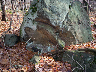
Now I have written about this beautiful cairn here before. Walking around to the front I found the following:
Which kind of reminds me of a Native American Prayer Seat. There is no trail in this area. It's very rough terrain. If the glacial debris doesn't trip you up,the vast amounts of thorn bushes will finish the job. From here we followed along the edge of a sort of bowl like gully when we ran across this:
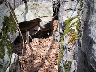
Though you can't tell from the photo - because there wasn't alot of room on the rim to get a cutaway shot. The front of this looks like it's been modified by a human hand. Width wise - you can walk right in there single file. The thing as a whole is straight, then circle like (inside) then back to narrow straight.
This photo was taken from inside the narrow opening. As you can see - there is plenty of room. On the right hand side it looks like a funnel to catch water. I got the feeling being in there that it's set up at an angle at the top - so that all you had to do was put a couple of animals hides up there and you would have a nice rock shelter.
This is on the left hand side - these rocks looked fire burnt to me, besides triangle-like. From here with the next picture I am heading to the back end of this thing.

Ohio Serpent and Alligator Mounds

Interesting update http://ohio-archaeology.blogspot.com/ on the Mounds of Ohio.

Thursday, January 28, 2010

Neat Looking Boulder off of Decker Avenue

Again, I know this is subjective and not really much of anything. But this boulder reminds me of an animal rising out of the earth.


Also check out this and this and this from the same site.

Tuesday, January 26, 2010

Nice Size Beech Tree

This is MS a guy I work with - that once in a while I can convince him to trek along with me in my searches.
 
Posted by Picasa

Monday, January 25, 2010

Animal Like Head - Mountain Road

I know that this is subjective - but this looks like a turtle head to me. Even though I don't do a good job showing it. The boulder is propped up on an angle by a couple of rocks.

This is located just off of Mountain Road - along the right hand side of an old trail that winds it's way towards the Conemaugh Gap.

This is in an area that used to be part of a farm owned by one of John Brown's boys.

Other side that shows the crack goes the whole way round.

Sunday, January 24, 2010

Large Boulder - Rock on Rock

I look at this thing everytime I go up this part of the Mountain Road. Sometimes I think it could be something and other times I think not. It's just hard to tell.

Posted by Picasa
This is located in the same area as these.

Saturday, January 23, 2010

Sunken Pit

It's probably hard to tell from this picture taken at the same area. What you are looking at is a nice sized 4 x 4 (roughly) sunken pit.
Posted by Picasa

Friday, January 22, 2010

Prayer Seat?

This might be stretching it, but this possible structure kind of reminds me of a Prayer Seat. This is located just off to the left of the first dirt road off of Decker Avenue.

Posted by Picasa
There is also the remains of an old spring here at this site. I will be posting more pictures from there. It's hard to get a clear line. It has certain aspects to me of being ceremonial in a way. But I've only been there once and need to go back to get a better read of the land.

Thursday, January 21, 2010

Brown's - Lower Yoder Township

This rockpile made up of flat-type rocks is located just off the dirt road heading to Brown's from the Sons of Italy Road. This is one of two there that I have found so far.
 
Posted by Picasa

Wednesday, January 20, 2010

Tuesday, January 19, 2010

Rockpiles at Brown's Farm - Lower Yoder

This pile from the way it looks and is laid out - reminds me of an old-time grave.

These two rockpiles are part of group of many. They go from small to large.


Monday, January 18, 2010

15,000 Dead Birds...Thump...Thump...Thump

It's birds vs planes at the Centre County Airport and the birds lose.  This explains the situation much better than I could. Consider that the airport doesn't even have a control tower. Maybe instead of whacking  the birds off they should teach them how to run the airport instead. Granted they would build the control tower out of sticks and such. And the first strong wind, down it goes...but they could just rebuild....rebuild...rebuild (it'll keep them away from the planes). An eagle could be the official spokesbird (since they're so majestic). Get a couple of bluejays to help keep the employees in line and watching over them could be the turkey vultures. Since everything means lunch to them. This might solve their bird-brained scheme.

Or better yet, get the guy with the gun that shoots blanks in State College. He has been trying to ask the crows nicely at Penn State to move on out. Maybe they could work a deal out with the airport birds too and get Hitchcock to offer THE BIRDS a movie role. Or better yet get Heckle and Jeckle (they could be in customer service), Woody Woodpecker, Tweetie Bird (a trouble maker that one and would get the union all worked up I bet), the Road Runner (when Wylie E Coyote wasn't chasing him)  and Foghorn Leghorn (to deal with the federal government) to come out of retirement to talk some sense into these feather brained terrorists whose grand scheme is to pick us off, one by one.

Sunday, January 17, 2010

Laurel Hill Webcam

With all our warm weather in the last couple of days, some of the snow coverage is melting. On top of this part of Laurel Hill its gone down about at foot.

Saturday, January 16, 2010

Possible Manitou Stone

This stone is near a couple of rock piles and split-wedged rock-on-rock here and a possible burial mound here.

Posted by Picasa

Tuesday, January 12, 2010

Going Green in the Conemaugh Valley

This is a very pretty area on the lower end of the old Son's of Italy Road just off of St. Clair Road. What's left of this road travels the whole ridge line of the mountain and will eventually take you to Westmoreland and Indiana Counties. You can take this road to Brown's Farm - but it's kind of the long way to go about it. Hugh sections of this road are washed out and basically unless you walk it - the only other way to travel along it is by ATV..

Just a taste of what's wanting for us under all this snow.

If you click here you can see more of what is believed to be a Native American Serpent type wall. That also contains a group of rockpiles and smaller walls.

Hard to tell from this photo but if you click here there is a possible sunken burial cairn(rockpile) mound.

Two deer playing near an old tree along the edge of Sunnehanna Golf Course - Stackhouse Park.

Nice little Turtle Pond - Stackhouse Park

One of the trails that skirt along the side of Haws Pike (Route 56).

This bit of green is along the old Son's of Italy Road.

You can see more from this site here.

Sunday, January 10, 2010

Part 3 - Standing Stone Area with Rockpiles

Larger sunken rockpile made up of smaller size stone that seem to be anchored by a couple of boulders. These piles do not seem to be the field clearing type( research has found no known farms were in this area). Also this group of rock mounds seem to have been made during different time frames. Some look much older, besides having a different style or look.

This type of rockpile is make up of the smaller size stone.

Larger size stones make up this rockpile.

This is the other 350+ year old tree at the site. She's even bigger than the first tree.

Saturday, January 9, 2010

Part 2 - Standing Stone Area with More Rockpiles

Another shot of the very old tree that seems to be guarding the site.

Nice size rockpile - this end of the group - the size of the rockpiles are larger. They don't seem to be of the field clearing type. There also seems to be a layout to the whole area. With smaller rockpiles in one section and large in another.

Another large rockpile - slightly sunken in the middle.

Rock on Rock - in the middle of a group of rockpiles - it's actually pointing to the picture above.

Also click http://laurelhillwalks.blogspot.com/2009/11/this-cairn-is-part-of-many-in-area.html and http://laurelhillwalks.blogspot.com/2009/12/possible-burial-cairn.html for more from the same area.

Friday, January 8, 2010

Laurel Ridge Webcam - Snow Depth Measurement

I want to post this picture taken today from the state webcam at Laurel Ridge State Park. All this snow is why I have been posting archive photos. It has snowed everyday since before Christmas. With no end in sight yet. There is a fresh 4" this morning with more on the way again tonight - this time it's Lake Effect. At this rate - I won't be able to get out and search for new sites until spring.